Tactile Map for Taipei Metro Route
pinshape
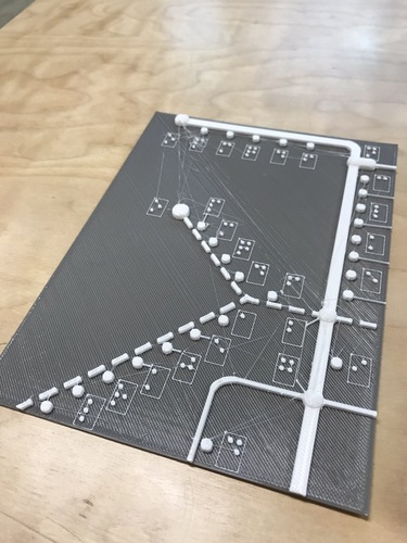
While Taipei Metro expands from one line to five lines, it's made city commuting more convenient, but also challenging for visually impaired friends when transferring between different lines. This tactile map of Taipei Metro Route is specifically designed for my friend, featuring braille in traditional Chinese, with an English version to follow after some updates. The current map consists of four sections, each approximately 18x14cm, which can be connected through oval symbols representing transfer stations by the edges. The full station names would take up too much space, so only the first letter is included next to each station in Mandarin Phonetic Symbol sequences. Station names are grouped by metro line for quick reference in a separate list, with examples of lines represented by different types of lines: Red Line—single thick line, Blue Line—single thick dot line, Orange Line—single thin dot line, Brown Line—double thin line, and Green Line—single thin line. When using the map, users can find the representing symbol and line of the start station in the list, then locate the end station in a similar manner. By considering the shape of the line, users can determine where to transfer and how many stops are between stations. I've printed and reviewed this beta version with my blind friend, confirming that the height of the dots and lines is distinguishable, although some braille spacings need fine-tuning for perfect readability. The edges are still a bit sharp, but I'll try printing with PolySmooth and vaporizing the prints with Polysher to improve texture. The entire map set is too large to carry, so my next step will be adding hinges or pasting the prints on soft cloth to make it foldable or book-like after my friend is satisfied with the arrangement and texture. The model was created in Tinkercad Beta, which allows direct input of braille, significantly saving time. For Chinese braille conversion, I use a web tool designed by a visually impaired Taiwanese engineer: http://coscell.molerat.net/brl/c2b.php. These resources have greatly simplified the process of creating 3D braille, and I'd like to express my gratitude to the developers behind them!
With this file you will be able to print Tactile Map for Taipei Metro Route with your 3D printer. Click on the button and save the file on your computer to work, edit or customize your design. You can also find more 3D designs for printers on Tactile Map for Taipei Metro Route.