Queensland
prusaprinters
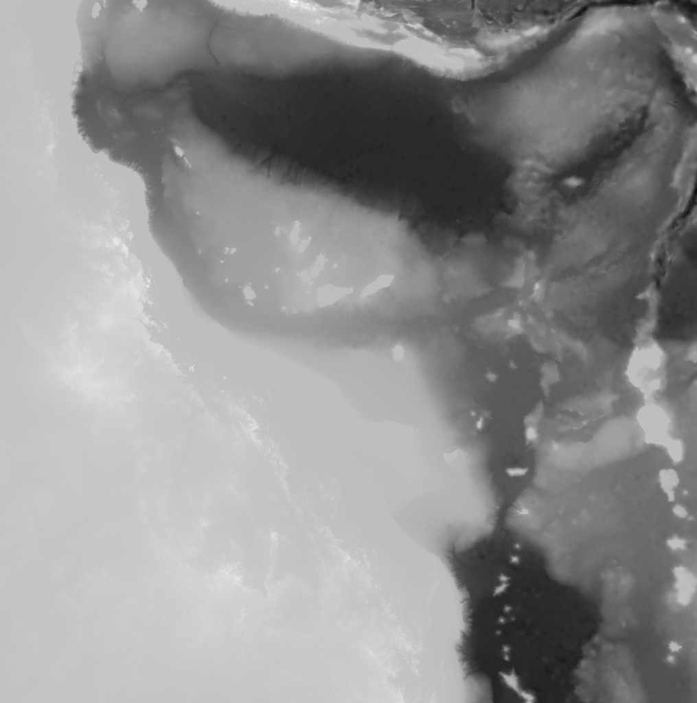
<p>This print was contracted by the Australian Institute of Marine Science. It's a map of Queensland, Australia. The map was created using the bathymetry data from DeepReef.</p> <p>Map to scale:</p> <ul> <li>Horizontal = From West to East, the map is approximately 1900km.</li> <li>Vertical = From the deepest ocean to the tallest mountain, this map is only 8km tall.</li> </ul> <p>Greyscale image scale:</p> <ul> <li>Black = -6000m</li> <li>White = 2000m</li> </ul> <p>The coastline is exactly at 2/3 of the total height.</p> <p>Source:</p> <ul> <li>Bathymetry: <a href="https://eatlas.org.au/data/uuid/200aba6b-6fb6-443e-b84b-86b0bbdb53ac">https://eatlas.org.au/data/uuid/200aba6b-6fb6-443e-b84b-86b0bbdb53ac</a></li> <li>png23d: <a href="http://kyllikki.github.io/png23d/">http://kyllikki.github.io/png23d/</a></li> <li>Blender: <a href="https://www.blender.org/">https://www.blender.org/</a></li> </ul> <h3>Print Settings</h3> <p><strong>Printer Brand:</strong></p> <p>Prusa</p> <p class="detail-setting printer"><strong>Printer: </strong> <div><p>i3 MK2S</p></div> <p><strong>Rafts:</strong></p> <p>No</p> <p class="detail-setting supports"><strong>Supports: </strong> <div><p>No</p></div> <p><strong>Resolution:</strong></p> <p>0.1mm</p> <p class="detail-setting infill"><strong>Infill: </strong> <div><p>20%</p></div> <p><strong>Notes:</strong></p> <p>This print is quite large (155mm x 156mm). I recommend cranking up the bed temperature and using brim for printing, to avoid warping.</p> <p>Be ready to wait for a very long time! This print took 31 hours 24 minutes to complete on my 3D printer.</p> <p>If you want to do a multi-colours print like mine, try to calculate a proper Z scale / layer height which will put the 0 (coastline) between 2 layers. The settings I used for my print:</p> <ul> <li>Z scale: 87.64940239%</li> <li>Z height of the first blue layer: 6.7mm</li> <li>Z height of the first sky blue layer: 16.6mm</li> <li>Z height of the first orange layer (coastline): 19.9mm</li> </ul> <p>Please share your results!</p> <h3>How I Designed This</h3> <ol> <li>I created a greyscale image from the Bathymetry, using GeoServer. This step can also be done using QGis or ArcMap.</li> <li>I created a STL file from the greyscale image using the png23d library.</li> <li>I engrave the client logos under the map using Blender.</li> </ol> <p>Note: Blender is a free CAD program. It's very powerful but it can be hard to use at first. I strongly recommend learning and using Blender for your 3D projects since it produce error free STL files, ready for 3D printing.</p> </p></p></p> Category: Models
With this file you will be able to print Queensland with your 3D printer. Click on the button and save the file on your computer to work, edit or customize your design. You can also find more 3D designs for printers on Queensland.