Philadelphia 3D model
cgtrader
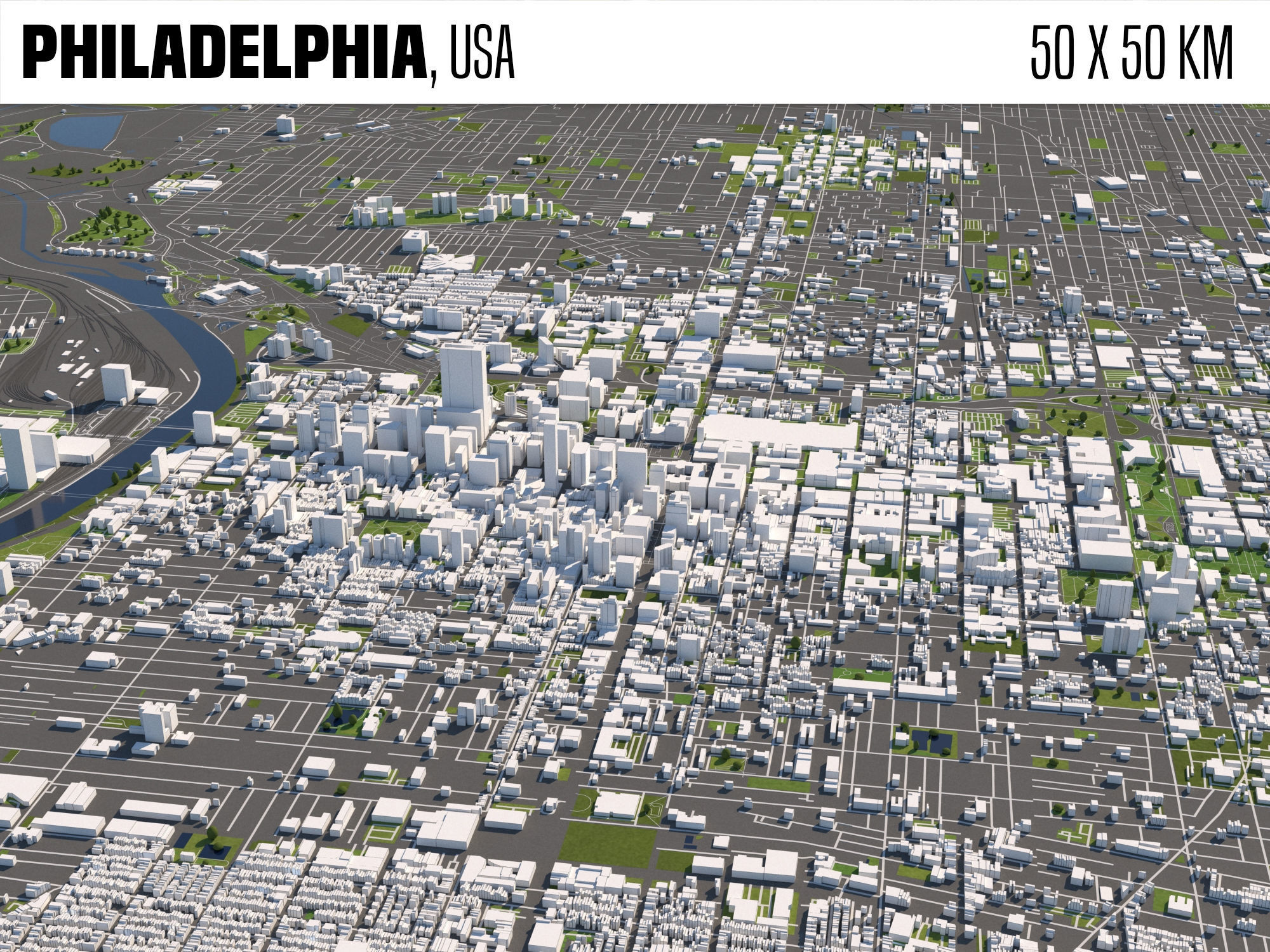
SCENE INFORMATION The area covers an enormous space of 50 x 50 kilometers in diameter. This intricate model is built from precise OpenStreetMap data. The scene is specifically prepared for seamless integration with 3ds Max and V-Ray Next software. Each image within the scene was rendered using cutting-edge V-Ray Next technology. Though it's possible to use the asset with older V-Ray versions, results may not meet expectations due to outdated features. Pre-rendered images displayed as preview serve as a valuable insight into the scene's contents. Standard units employed in this model are metric and based on centimeters. A remarkable aspect of the asset is its usage of real-world scale accuracy. Users have the option to export models using collapsed mesh formats, making it versatile and efficient. In case you require extra assistance or support with your model, don't hesitate to contact our dedicated support team. DISCLAIMER The ultimate purpose of this digital creation is its flawless optimization for seamless operation within 3ds Max software in combination with V-Ray Next rendering engine. Each and every single material used throughout the asset was meticulously crafted using advanced features of V-Ray technology. Virtually all lights utilized in the scene were strategically placed to function efficiently as V-Ray light sources. Important to note: Although VRay settings have been perfectly optimized, translation may vary slightly with different export formats. Utilization of other software and renderer packages will inevitably produce varied outcomes and results not directly supported by the artist's team. We kindly request that our users avoid usage of assets in conjunction with foreign rendering tools as support cannot be guaranteed or given in such cases. GEOMETRY In its compact, space-saving design, all objects within the scene have been cleverly placed upon a flat plane. Upon examination of the layered organization structure it is easy to see the thoughtful application of each and every layer including (buildings, highways, railroads, water). Layers enable easy categorization and management, thus improving efficiency and workflow for those using 3ds Max and other similar software. Note that, unfortunately, due to technical import restrictions or absent data not all buildings were included within the original imported model from OSM. Nonetheless a precise visual illustration of this area can be seen in our accompanying preview images detailing what exactly is encompassed within our finished asset. Preview images effectively outline all omitted buildings/buildings excluded from the design based upon restrictions. Furthermore landmark structures only partially built due to lacking and missing OSM data can also be visualized via the included render-outs. Since land-mark details weren't explicitly mentioned, an easily discernable absence can often suggest such was a deliberate decision of not to include for the betterment or improvement of said landmarks for all other scenes that are possibly used in future production. No altitude data available means our scene remains level with a 'no height information' structure - resulting into flat map representations without elevations. Tree's individual counts (1416160 Poly-count, 743464 Vertices) signify large complexity when it comes to overall design intricacy due to multiple tree formations displayed as standard object (box modeler property). However please keep in mind we can also export mesh objects, which means models have more complex structures if you prefer such type. All visible trees, whether included within an open field, under covered space, are perfectly represented through V-Ray plane at global 0 coordinate, i.e the top-right corner and middle-left origin coordinates set equal zero to maintain symmetry and even design aesthetic for our flat landscape visual display model which uses no extraneous rendering effects. Please remember that in order to reduce computational power V-ray render will not output planes which is crucial here to avoid added lag time between user inputs, so all rendered views only include final assets of models used such as: buildings or objects found within said scene. MATERIALS To efficiently create photorealistic environments this digital 3d creation heavily depends upon optimized application of VRay Materials which not only allows designers but developers too to add a certain level depth into textures thus adding an immense dimension without sacrificing detail while using multiple layer UVw-maps which can easily get un-done by those who may have difficulty working at a fast speed. Varying combinations could help reduce the number required texture file size, however note some users should only try such techniques once getting well-versed with 3ds Max's tools especially considering that applying different kinds of effects using other available software won't be entirely compatible. The end goal remains clear – all objects remain within a perfect V-Ray rendered model while textures have realistic qualities without having added excessive poly-count. Each texture applied is specifically designed to create precise visual output for the particular 3d models in question. So as per requirements users can select desired color patterns via UV-map, enabling flexibility according to one’s project specific goals while preserving standard rendering engine performance without slowing down export process. LIGHT SETUP As it happens our expert-designed light setup features V-Ray sun along with dynamic sky. Furthermore it uses Linear Workflow resulting in an enhanced visual outcome when rendering images from this model. This highly sophisticated setup not only allows us artists achieve photorealism but ensures maximum compatibility and efficiency when rendering. FORMAT
With this file you will be able to print Philadelphia 3D model with your 3D printer. Click on the button and save the file on your computer to work, edit or customize your design. You can also find more 3D designs for printers on Philadelphia 3D model.