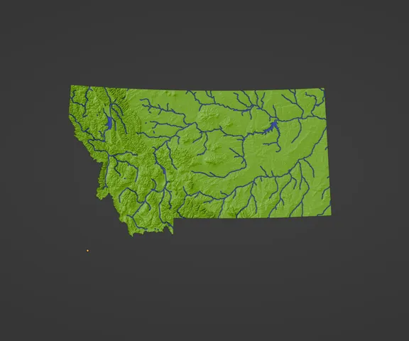
Montana, USA (MT) Topographic Map with Rivers
prusaprinters
Montana, USA (MT) Topographic Relief Map with Rivers and Coastal WatersMontana, USA mountains, coastlines, streams, and lakes in a dual or single color topographic and hydrographic map! All topographic states in the USA of Plastic project are at 1:2500000 scale and interlock with each other similar to a puzzle.Show off streams, lakes, and coastlines with filament that is glow-in-the-dark or translucent — or simply use a different color from the base!Model and Map SpecificationsRecommended 3D Model Files to Print ↓ See 🌟 or ⭐ ↓MT-sqrt-dual.3mf 🌟 (Dual extrusion only ⚠)MT-sqrt-single.3mf ⭐ (Single/Dual extrusion OK)Recommended to download only the model file name you need for faster download and less storage usage.Model Filename ChartSTATE-ESCALING-EXTRUDER-STYLE-REVISION-PIECE##.3mf │ │ └────────VARIANT────────┘ DefinitionMeaningSTATEState AbbreviationESCALINGLinear or Square Root (sqrt) elevation scaling.EXTRUDERDual or Single color (extrusion) modelSTYLE* (optional)Model special style or subregion. STYLE is only present when the model file is a special style or the model is exclusive to a special subregion.REVISIONRevision number. See release notes for the latest improvements.PIECE##† (optional)Interlocking pre-cut piece ## sized for 180 mm x 180 mm bed.*Default STYLE is water features model located over submerged low lying lands. This submerged land may be visible when water layers are printed with a transparent filament. Default style minimizes usage of secondary (water) filament color. transparent style has water model features that extend all the way through the land for maximum light transmission when used with glow and transparent filaments.†If multi-part files are not present, I have not created interlocking models for this state yet. Follow me and comment with your request to get future additions and updates.The models are in 3MF format which is like STL but better. 3MF has smaller file size and can store separate land and water objects that are aligned for easy dual color prints. 3MF is supported in Cura, PrusaSlicer, and other 3D slicers.Recommended print settingsPrint the model flat. You can do a manual color change mid print to get interesting color transitions at higher elevations. Printers without multi-material capability should print the *-single.3mf models.Download the optimized Cura print settings profile for topo maps HERE.You can scale the model up or down as needed to fit your printer size, the final map's scale will just be scaled accordingly. E.g. 200% scale on a previous scale of 0.4mm:1000m results in 0.4mm:500mIf you rotate or scale models to fit your printer in Cura, merging objects (Ctrl+Alt+G) beforehand will help keep the dual color print objects aligned.Printing this will test your 3D printer's XY precision, Z-axis stability, retraction, cooling, and oozing!Slicer SettingRecommended Value for 0.4 mm nozzleLayer Height0.1 mmLine Width0.4 mmMinimum Thin Wall Line Width0.2 mmTop Surface Skin Layers2Top Surface Skin PatternLinesSkin Overlap20%Top/Bottom Flow100%Top Surface Skin Flow100%Infill and Infill PercentageLightning 30%Ironing Line Spacing0.2 mmIroning Flow20%Ironing Inset0.34 mmIroning Speed60 mm/sBrim ExtruderExtruder 1 or 2Ooze ShieldYesNeed a special location/map modeled and printed as a showpiece or gift? Contact me (maps@ansonliu.com) for design and production services to bring your idea to life!CreditsUSAofPlastic topographic map project uses data from NASA SRTM V3.0, USGS GMTED2010, USGS HYDRO1K based on 1996 GTOPO30, HydroLAKES, and USCB TIGER/Line.Tools used include QGIS, GDAL, GRASSGIS, TouchTerrain, Anaconda, GeoPandas, Matplotlib, Blender. Please support open data and FOSS software.Tags topography dual usa hydrography usaofplastic transparent topographic hydrographic rivers lakes streams mountains forests canyons valleys wall map cartography gis dem
With this file you will be able to print Montana, USA (MT) Topographic Map with Rivers with your 3D printer. Click on the button and save the file on your computer to work, edit or customize your design. You can also find more 3D designs for printers on Montana, USA (MT) Topographic Map with Rivers.
