La Palma Islas Canarias spain
myminifactory
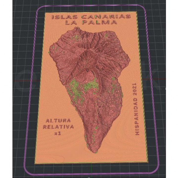
Altura de capa la mínima que puedas, 0.06 seria buen valor. Islas Canarias. La palma. Spain. Volcán. Acede directamente al mapa desde este enlace. Hazlo tu mismo. touchterrain.geol.iastate.edu/?trlat=28.910581467133884&trlon=-17.695521365739218&bllat=28.432869477136567&bllon=-18.021754285208704&DEM_name=JAXA/ALOS/AW3D30/V2_2&tilewidth=120&printres=0.2&ntilesx=1&ntilesy=1&DEMresolution=53.15&basethick=1&zscale=1.0&fileformat=STLb&maptype=roadmap&gamma=1&transp=20&hsazi=315&hselev=45&map_lat=28.64662831790257&map_lon=-17.849080997757188&map_zoom=11 You also have the STL, in:drive.google.com/file/d/1tYRD4dqc7dAt_gBRCl4TyhODhCX3P91o/view?usp=sharing The minimum layer height you can, 0.06 would be a good value. Canary Islands. The Palm. Spain. Volcano. thingiverse.com/thing:4982585 Access the map directly from this link. Do it yourself. touchterrain.geol.iastate.edu/?trlat=28.910581467133884&trlon=-17.695521365739218&bllat=28.432869477136567&bllon=-18.021754285208704&DEM_name=JAXA/ALOS/AW32030/1695521365739218&bllat=28.432869477136567&bllon=-18.021754285208704&DEM_name=JAXA/ALOS/A&W32030/6596521365739218&bllat=28.432869477136567&bllon=-18.021754285208704&DEM_name=JAXA/ALOS/AW32030/165/1/29/1/1/12030/1/1/29/1/1/12030/1/1/1/12030/120930/1208704&DEM_name=JAXA/ALOS/AW32030 = 1.0 & fileformat = STLb & maptype = roadmap & gamma = 1 & transp = 20 & hsazi = 315 & hselev = 45 & map_lat = 28.64662831790257 & map_lon = -17.849080997757188 & map_zoom = 11
With this file you will be able to print La Palma Islas Canarias spain with your 3D printer. Click on the button and save the file on your computer to work, edit or customize your design. You can also find more 3D designs for printers on La Palma Islas Canarias spain.