Earth topography with coastlines
thingiverse
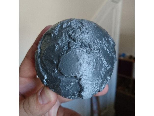
This is a highly detailed globe of Earth's topography, designed with education in mind. Several others exist on Thingiverse already, but this one stands out for its raised continent outlines, making it easier to identify familiar coastlines and perfect for teaching purposes. Two hollow hemispheres are included, printed with minimal plastic and no supports required. A complete sphere is also provided for those who want to print using more advanced methods or repurpose the model for another use. Update: For a challenge, try printing the model that opens to reveal its core with embedded magnets (https://www.thingiverse.com/thing:3561651) or crustal thickness (https://www.thingiverse.com/thing:3899023). Recommended study topics include: Hawaii, located in the Pacific Ocean, is part of a long chain of submarine mountains formed by volcanoes as the ocean plate passes over an unusually hot part of the Earth's interior, known as a "hot spot" or mantle plume. How many of these tracks can you find? Mountain belts form at convergent plate boundaries where one tectonic plate collides with another. The Himalayas are a great example; how many more can you identify? Ocean trenches exist where one plate subducts beneath another, creating an extremely deep ocean. The deepest of these is the Mariana trench in the northwest Pacific Ocean. Where else can you find subduction happening? Why do the trenches often adjoin a belt of mountains? A ridge runs down the middle of the Atlantic Ocean, marking where new oceanic crust is created. Where are the other mid-ocean ridges located? Print Settings: Printer Brand: Wanhao Printer Model: Wanhao Duplicator i3 V2 Rafts: No Supports: No Resolution: 0.1 mm Infill: 20% Notes: Printed without a raft or supports; the hollow sections are able to bridge at the top. For high-quality prints with minimal infill, follow these guidelines: Print with at least six base layers and ten top layers for a good finish over the infill. Print with two walls, but go slow! There are many direction changes in the outer skin, so print at 60 mm/s for the infill but only 20 mm/s for the exterior. If your printer is very rigid, you may be able to increase speed. Make sure your z-height is well calibrated; a good first layer is essential for a seamless finish. Post-Printing: Glue two halves together with superglue. I printed in HatchBox Silver PLA at 200C, which looks fantastic... Design Details: Surface height data source: ETOPO1 (https://ngdc.noaa.gov/mgg/global/global.html) Surface height was scaled using a black-to-white monochrome image generated using the Generic Mapping Tools (GMT - http://gmt.soest.hawaii.edu). A second image depicting coastlines was created, and these were combined using ImageMagick tools. The 3D model was created by applying this image as a bump map to a standard sphere in Blender (https://www.blender.org/) and exporting as an STL. The model was then sliced into hemispheres and hollowed out using MeshMixer (http://www.meshmixer.com/).
With this file you will be able to print Earth topography with coastlines with your 3D printer. Click on the button and save the file on your computer to work, edit or customize your design. You can also find more 3D designs for printers on Earth topography with coastlines.